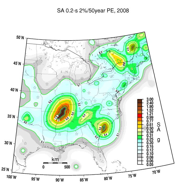
I realize that this is an unusual thing to do, but I have started monitoring earthquake activity in the United States. For some reason, probably the recent earthquake in Japan, I have been interested in earthquakes, and how common they are in certain parts of the world. I was a little surprised to know that there is a major fault zone in the central United States.
I was really surprised that there is an easy way to track earthquakes using the United States Geological Survey notification system. After creating an account you can get an email sent when an earthquake occurs, and you can filter them based on region and magnitude as you wish. Here’s a sample notification:
3.5 Ml – CENTRAL CALIFORNIA
Preliminary Earthquake Report Magnitude 3.5 Ml
Date-Time
* 30 Jun 2011 22:03:24 UTC
* 30 Jun 2011 15:03:24 near epicenter
* 30 Jun 2011 16:03:24 standard time in your timezone
Location 36.457N 120.365W
Depth 8 km
Distances
* 7 km (4 miles) SW (220 degrees) of Cantua Creek, CA
* 23 km (14 miles) SW (223 degrees) of San Joaquin, CA
* 24 km (15 miles) SSW (206 degrees) of Tranquillity, CA
* 35 km (22 miles) N (359 degrees) of Coalinga, CA
* 168 km (104 miles) SE (125 degrees) of San Jose City Hall, CA
Location Uncertainty Horizontal: 0.3 km; Vertical 0.6 km
Parameters Nph = 59; Dmin = 13.0 km; Rmss = 0.22 seconds; Gp = 68°
M-type = Ml; Version = 2
Event ID NC 71593265
For updates, maps, and technical information, see:
Event Page
or
USGS Earthquake Hazards Program
CISN Northern California Management Center
U.S. Geological Survey
Berkeley Seismological Laboratory
http://www.cisn.org/ncmc.html
Disclaimer
Note that if you select a low magnitude for the threshold for notifications you will have quite a few emails sent to you, as minor earthquakes are surprisingly common. I was surprised by how many earthquakes occur in Alaska and California. There are numerous ones that don’t make the news, and cause little damage. Makes you wonder if they are building up to a big one?
There are also some cool historical charts and other data. Here’s one that I particularly found to be interisting.

So those of you in Memphis- do you have earthquake insurance? I don’t believe I do (I need to check with my agent). I wonder if the next Katrina-like event (besides our national debt crisis) could be a major earthquake?
Another question: What the heck is going on in central Arkansas? (Besides the obvious, which I won’t go into, as I’m not a genealogical or genetic expert.)
Some have speculated that it is “fracking” for petroleum products. I wonder is there is a resource that shows where these “fracking” operations are conducted?


